|
|
||
|
|
MIGRATIONS #9 Past Present 15 April 2008 - 26 June 2008 Written July-August
2008 In many places it is possible in the light of great monuments to reconstruct the past. In Easter Island the past is the present, it is impossible to escape from it; the inhabitants of today are less real than the men who have gone; the shadows of the departed builders still possess the land. Voluntarily or involuntarily the sojourner must hold commune with those old workers; for the whole air vibrates with a vast purpose and energy which has been and is no more. What was it? Why was it? The great works are now in ruins, of many comparatively little remain; but the impression infinitely exceeded anything which had been anticipated, and every day, as the power to see increased, brought with it a greater sense of wonder and marvel. Katherine Routledge, The Mystery of Easter Island, 1919
I doubt anyone who visits Rapa Nui can write a better description of the sense of the past that pervades one’s life on Easter Island. Routledge and her husband, in the great tradition of English Gentlemanly Exploration, built a 90-foot sailing yacht and journeyed half-way around the world via the Straits of Magellan to conduct archaeological, historical and societal studies on Easter Island. The expedition ran from 1913 through 1916 with 1½ years spent on the island itself. Routledge interviewed many of the old people of the community just weeks before they passed away. They were the last links with a culture that died with them, and was itself the fading tendrils of a society that built some of the most wondrous monuments known. Without the work of Routledge and her husband, the mysteries of Easter Island would overwhelm us. Even with their efforts, and those of many others since, the questions outweigh the answers. Thus the “wonder and marvel” Routledge wrote of became an addition to Migration's crew list during our five weeks at Rapa Nui.
The reason that so few boats visit is because the island lies far from the popular cruising routes (for example, Panama to Polynesia to New Zealand) and it has no safe all-weather anchorages. Being in the zone of variable winds between the Southeast Trades and the westerly-blowing Roaring Forties, the winds and waves can change velocity or direction quickly. And they do. There are four useable anchorages around the island and (as you’ll see) there are times when not one of them provides shelter. Thus we were always aware, and wary, of the weather – receiving forecasts via our HAM radio and stopping in at the Chilean Navy’s office for their latest report. This was all a big change for us. Though we always think about the weather, we had rarely been in a place where the wind would change direction 180 degrees and triple in velocity in a matter of hours, thus endangering the boat.
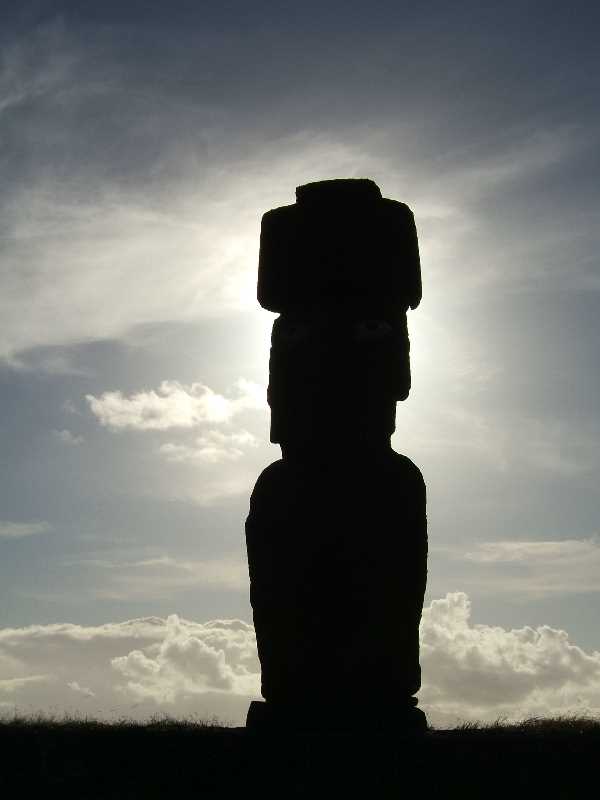
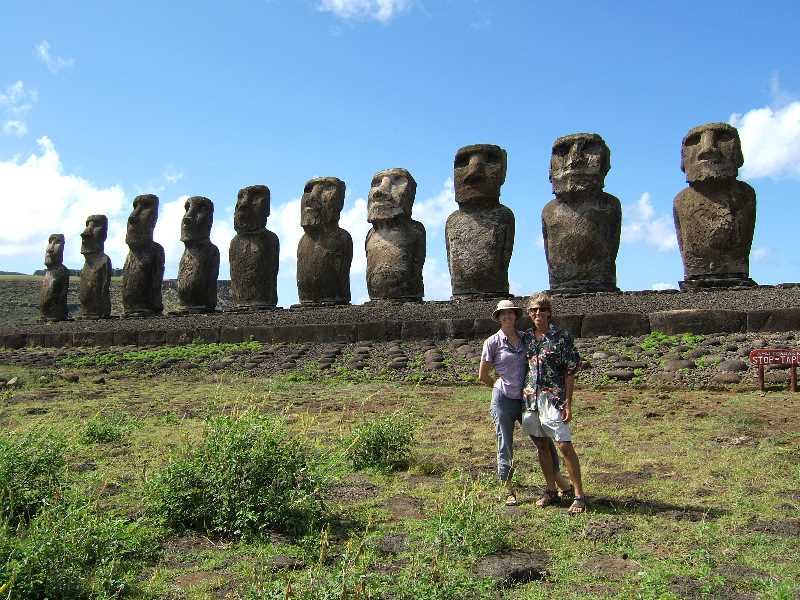
Ahu are ritual platforms. Some are simple mounds while others are huge platforms constructed of finely hewn stone fitted together with perfection. There are about 350 ahu on the island. Some had moai (the great stone statues) on top, some did not. During the 19th century all of the moai were toppled; probably because of clan warfare but no one knows for sure. When Routledge arrived in 1914, there were no moai standing. Today, many ahu have been reconstructed and several have standing moai. The Tongariki ahu has a line of 15 moai which include the tallest currently standing. The ahu is also just below Rano Raraku—the volcano containing the quarry where all the moai were carved. We woke each morning to see the sun rising astern illuminating the moai standing under the volcano on our bow to the west. There were towering lava cliffs to our north and crashing surf to the south. It was wonderful.
We snorkeled in the chilly, and sometimes rough, waters and took several hikes. Then it was time to return to the main anchorage at Hanga Roa for provisions and internet access.
TIME PASSING We spent the next week exploring archaeological sites. We biked (and pushed the bikes) to the top of Rano Kau volcano to visit Orongo, the ceremonial village of the Birdman Cult which flourished on the island for many centuries.
Another bike ride took us inland and along the coast north of Hanga Roa where we visited more ahu, many caves, and ruins of ancient boat-shaped houses. The roads are rough and rock-strewn; tough on our little folding bikes, but they keep going.
What is really cool about biking around the island is that there are archaeological remains everywhere. We'd be lost on a tiny dirt road and come across a moai lying in a field. There are places that look like fields of lava stone and as you get close you see that many of the stones are the scattered remains of an ahu. On Rapa Nui, it is impossible to escape the past.
On the First of May, winds from the southwest chased us back to Anakena. There, we loaded our scuba gear into Plover and headed around the point off Ovahe Beach. What a surprise to find the most incredible underwater coral canyons either of us had ever seen. There wasn't a great abundance of fish but the coral was unbelievable. The water was crystal clear with nearly 30 meter (100 foot) visibility. I wish we had an underwater camera so we could show you what it looked like. Imagine a miniature Bryce Canyon rising 15 meters (50 feet) from the seabed 22 meters (70 feet) down. Walls, ravines, pinnacles, cones, columns – all of coral, some looking like a strange conglomeration of Christmas trees designed by Dr. Seuss, others like perfectly sculpted modern art. It was one of our most memorable dives.
A few days later we returned to Hanga Roa where we stayed for yet another week. We did three more excellent dives. Then we visited the fine archaeological museum and, finally, the south coast ahu and Rano Raraku with Patrice, a wonderfully knowledgeable Frenchman, as our guide.
I
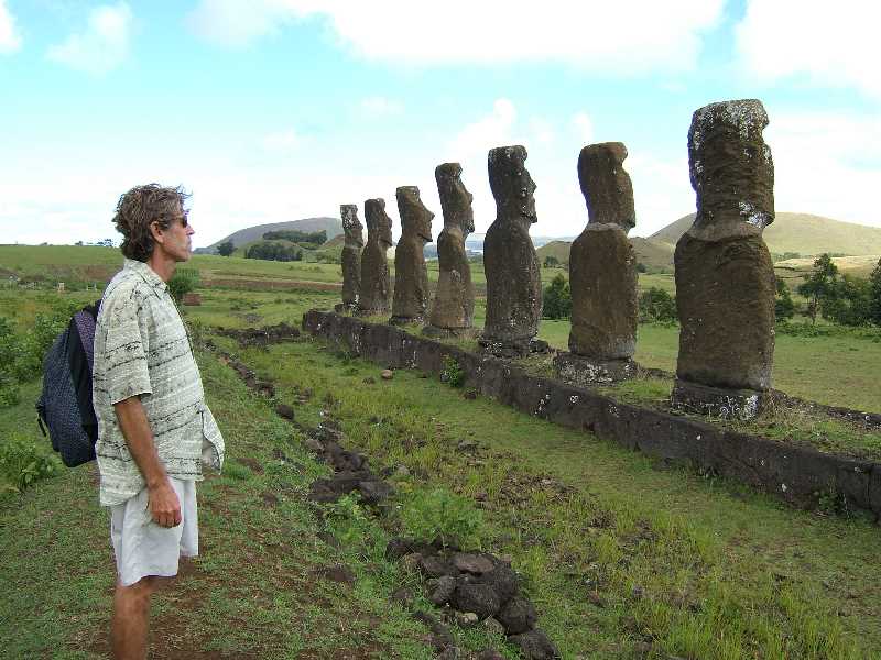
Rano Raraku is the volcano where all the moai were carved. The hillsides on the inside and outside of the crater are covered with moai in all stages of construction—some just started, some ready to be lowered down the cliff, others set upright for finishing touches. Over 300 completed moai were moved to ahu around the island, or abandoned on the roads that lead away from the quarry. No one is sure how they were moved; the largest are over 10 meters (33 feet) tall and weigh many many tons.
Nearly all the ahu moai face toward the island, not out to sea.
Ceremonies and burials were held in the areas before the ahu
with the moai looking on. It's said that the moai are not
depictions of gods but of forebears given an almost godlike status.
No one knows for sure. We wondered why, if the moai represent
ancestors, are their facial features so different from the Rapa Nui?
TIME PASSING
The southern winter was approaching. From Anakena we hitchhiked across the island to Hanga Roa to buy provisions and check-out with the Chilean Navy. We were planning to leave as soon as the rough weather abated. However, representatives from the Navy, Immigration and Health departments were required to board Migration before we left. They understood that we could not return to Hanga Roa due to the weather (waves were breaking completely across the harbor) and actually drove us, and our groceries, back to Anakena where we ferried them all out in Plover.
PAST
SUPERSTITIONS, PRESENT REALITY Our plan was to check out from Anakena, move to Hotuiti when the strong northwesterly started, wait for the wind to abate a little, and then leave as soon as possible. We raised our anchor Friday morning and by the time we were rounding the northeast corner of the island it was blowing above twenty. As we turned into Hotuiti we were surprised to see huge rollers breaking across the anchorage. In Anakena we had been protected by the large southeast swell that had developed. There was no possibility of anchoring as the waves were breaking far from shore – even in the area where we normally anchored which was very deep. Now the wind was really blowing. We stood off from the island and hove-to; a technique to keep the boat drifting slowly downwind with her bow more or less angled toward the waves. The wind continued to increase and in a couple of hours it was blowing a gale. The large swell was rolling in from the opposite direction and this created a very steep sea. It was clear we could not stay where we were. There was no longer a safe anchorage on the island. We had to leave. It was Friday. As the sun sank below Rapa Nui, we hoisted a reefed mizzen and a scrap of jib and headed north around the island. The seas were large and the wind was howling. We wanted to head west but that was where the wind blew from. The high steep chop created by the wind crashed into the swells rolling in from the other direction and created a confused and uncomfortable sea. Every so often a wave would slam into the side of the boat and then sweep across the deck. The wind was up and down over the next two days which, we both agree, were the worst days we’ve had at sea. Because of the large breaking waves we had a couple of things break aboard. But nothing that caused us too much hardship. Our Monitor self-steering gear was smashed by a wave and that required us to use the autopilot to steer. The Monitor uses the wind and the water to steer the boat, the autopilot uses electricity. Unfortunately, another casualty of the gale was one of our four solar panels which was smashed by a wave. Our ability to generate electricity was down 25%.
Pitcairn Island, our destination, was 1,100 miles to the west. We had looked forward to an easy downhill run with the wind behind us. Instead we sailed a circuitous 1,530 miles, nearly all of them against the wind.
Sometimes the conditions were very pleasant but more often they were bouncy and windy. Still in the Variables, the wind direction changed often. During one 24-hour period we saw wind from every direction of the compass with speeds from flat calm to 30 knots. Our log is filled with what seem to be contradictory comments, often on the same day:
OPPORTUNITY PASSED
We approached Henderson but, because of the rising wind and its direction, we couldn’t anchor. Alene was determined to set foot on the island so she suggested she swim through the breakers to the beach while I stood offshore in Migration. I reluctantly agreed. She donned her snorkeling gear, I maneuvered Migration as close as possible to the shore, and off she went. I retreated from the white water and watched her trying to time her entry through the waves. Close to the edge of the breakers she paused, started swimming, then paused again. I watched. When she began swimming away from shore I brought Migration around and picked her up.
Alene had found eight sharks patrolling back and forth along the edge of the coral shelf. She thought it wise not to infringe on their territory. I was glad she made that decision. We hoisted sail and coasted along the island watching the waves smash into the southern side sending white water higher than the high cliffs. Then we set our course for Pitcairn.
PASSAGES PAST Pitcairn is tiny; only 1.6 by 3.3 kilometers (about 1 by 2 miles). Anchoring at Pitcairn makes Easter Island seem like a marina. There are really no protected anchorages and it is not uncommon that boats and ships simply cannot stop. In fact, the previous three sailboats that called had not been able to visit.
The weather forecast showed a change in wind from the north to the southeast with a brief period of calm in between. We dropped anchor on the southeast side of the island at a spot called Downrope because there used to be access down the high cliffs via a rope. The anchorage was in rock; we didn’t like it but it was calm. The supply ship Braveheart was anchored a quarter mile offshore from us. It was preparing to depart and passengers and well-wishers were being ferried out in Tinny, the tiller-steered, metal Pitcairn longboat. On the way back to Bounty Bay, with about 15 Pitcairners spread around the boat, Tinny made a beeline for Migration. Everyone waved and welcomed us and, as they passed within a few feet (my heart beating hard as I looked at the sharp metal edge of the boat speeding past Migration's fiberglass and wood hull), one big Pitcairner—burly, bald, tattooed and pierced—threw a large plastic bag into my arms; a perfect shot through the rigging that nearly bowled me over. It was filled with 10 kilos of papayas, oranges and passion fruit. What a welcome! The next morning the wind dropped as expected and we motored in the cool mist around the point and dropped the hook in Bounty Bay. The boat landing is notoriously dangerous in the bay. A long concrete ramp hides behind a tiny jetty. Often the waves make it impossible to land—even for the Pitcairners with their expertise.
But who cared? We had made it to Pitcairn! We had a wonderful visit with Tom & Betty, their family, and Simon and Shirley. Tom and Betty are original Pitcairners and had great stories to share, along with Betty’s wonderful cooking (they invited us to stay for lunch). The rain didn’t stop but Betty offered us a ride around the island on the back of her 4-wheeler. It was a damp, muddy, and sometimes harrowing, ride. But well worth it. Betty’s stories punctuated every place we visited.
The wind changed direction 180 degrees and our anchor chain wrapped around a rock. We were able to maneuver Migration to free the chain and head out of the bay. With the last of the light fading fast, we hoisted the jib and set the autopilot. We tidied up, put Plover away, and stowed the fruit as the now 15 knot wind blew us quickly away—leaving Pitcairn behind; the lights of the island soon obscured by the rain. We’d sailed 1,500 miles over 15 days, encountered two gales and beat to windward for far too many hours. We spent 6 hours ashore.
It was worth it. PATHETIC PAST The Îles Gambier were once the home of nearly 10,000 islanders. In 1834, a French priest arrived and imposed a ruthless moral code on the locals, turning them into virtual slaves and forcing them to build a 1,200-seat cathedral. During the 37-year reign of Father Honore Laval, the population fell to 500. Another culture lost to colonialism and missionary zeal. The Îles Gambier consists of a partially submerged reef enclosing several volcanic islands. The town of Rikitea is on the largest island, Mangareva. About 500 people live there now, almost all of them involved in working the pearl farms which dot the lagoon.
PASSED PRESENTS
We had been warned about the price of food in French Polynesia but we were still surprised. In Rikitea, eggs were $1 each and a baguette cost $2.75. (We later found that most things, especially bread, were much cheaper in other places in Polynesia). But we were throwing a birthday party—what better reason to splurge. I decided to have the party a few days early as rain was forecast for the 10th. So on the morning of the 7th we invited the crew of the three other boats in the anchorage for appetizers and a pizza party that evening. The guest list would total seven people including us. However, as the day progressed three more boats arrived (including our friends from Rapa Nui, Tik and Lorraine on Ariel IV). We couldn’t leave anyone out so now we were 14. No problem, Migration has a big deck. The only problem was, about forty-five minutes into the party it began to rain. We grabbed everything and tumbled below. Now we were cozy. Fourteen in Migration's main cabin is a little tight, but everyone was in a great mood. I cooked four different types of pizzas (on the BBQ, thanks to the great recipe I have from Maureen and Riley on s/v Alouette de Mer). It was all good fun with everyone bringing extra food or drink, and even some presents for Alene. It’s so amazing that people you haven’t even met, who just pulled into the anchorage an hour before, come over with gifts! We finished the meal with birthday cake, of course.
PASSED PATHS About a mile later we were still in the brambles on the saddle of a ridge and clearly not on Mt. Duff. And the ridge was covered with… brambles. I gave James a break, took the machete and we forged ahead, finally freeing ourselves from the prickles and actually finding the mountain, then scrambling up its steep peak where we all plopped down to rest and nurse our scratches. We were nearly blown off the narrow peak when we stood up but the view from the top was awesome. It made the crazy hike worth it. We were more careful on the way down and, though we were lost briefly, managed to avoid too many more scratches. That night we continued with a birthday dinner aboard Migration with Tik and Lorraine. The next day, we ended the celebration with Alene’s favorite dessert, crème brulee.
We sailed across the lagoon to the coral atoll of Totegegie and spent a few days away from the town and the other boats. It was our first taste of Polynesian snorkeling and we were amazed by all the species of fish that were new to us. The coral was beautiful and Alene spent as much time in the water as she could. Unfortunately it was cold so that wasn’t as much as she would have liked.
We returned to Rikitea and, in between squalls, rainstorms and heavy winds, biked around the island, hiked a little more, visited with friends, did boat maintenance and spent several days filling our propane tanks. Every few days we bicycled up to a small farm to buy fresh bok choi, cabbage, onions and parsley. We ate our first pamplemousse—a delicious tropical cousin of the grapefruit.
I visited the students at the technical high school and we had a pleasant evening discussing books and writing—translation provided by Christiane, their wonderfully enthusiastic teacher. We visited with Christiane and some of the students a few more times—getting to know them was the highlight of our time in the Gambier. They kindly presented us with wonderful gifts upon our departure: shell necklaces, vanilla beans, carved mother-of-pearl, and a big jar of the most delicious honey we've tasted.
One night we set up our projector in the community hall and showed Mary Poppins (surprisingly well-dubbed in French) for the kids of the town. Another evening we attended the Rikitea Music Fete where the girls competed in traditional Polynesian dance while the boys danced hip-hop (badly). We were anxious to leave as the weather was just too cold and rainy for our taste. And frankly, except for some significant exceptions (Christiane and her students, for example), many of the people of Rikitea were a bit cool as well. They are quite well-off (everyone is driving a new 4WD truck—ridiculous on a small island where gasoline is very expensive) and focused on their pearl farming businesses. The celebrated hospitality of Polynesia wasn't evident there. After two weeks we headed out the pass and pointed the bow north toward the atolls of the Tuamotu Archipelago—The Dangerous Islands. Those travels are for the next update.
LOST PAST The ravages of slavery, colonialism, business ventures and missionaries erased most of what was left of the culture. Earlier in their history, the Rapa Nui themselves no doubt caused great strife among their population by continual clan wars and, possibly, deforestation. Still, the pain of this history solidifies in one’s heart when standing on this tiny remote island, awestruck by the great monuments and gazing on a long blue horizon. What was it like to see white sails on that horizon, creeping closer, until strangers landed and herded, at gunpoint, you, your family and friends, taking you from your home—the only life you’ve known—to a life of hard labor on a far-away island? In a few hours, everything changed. How is it possible that anyone can think they have the right to do that? My mind reels when I think of it; overwhelmed by the cruelty that can be taken for granted, and that has, and continues, to destroy people everywhere. PAST TO PRESENT We will soon be putting Migration to bed in Tahiti and flying to the United States. Americans are only allowed a 90-day stay in French Polynesia and our visa expires on 9 September. We’ll be returning to a country looking toward the future in the form of the upcoming presidential election.
I recently read Life Is So Good by George Dawson and Richard Glaubman. It’s the story of Dawson’s life and philosophy. He was born in 1898 and lived to be over 101. As a boy in rural Texas he watched lynchings. As a black American he dealt with the Jim Crow laws and racism at its most basic level in his home state and throughout his travels. His story was picked up by the media when, at the age of 98, he enrolled in school to learn to read.
As I read, with rage, the treatment he received through decades of condoned racism, I had to keep reminding myself that much of it occurred during my lifetime. As a native of the West Coast it is also important to realize that racial hatred is not confined to other parts of the country. Anaheim, California—home of Disneyland in the heart of blindly-Republican Orange County—was practically founded by Klansmen. It posted signs on its outskirts that read “KIGY” (Klansmen I Greet You).
Now, 110 years after Dawson’s birth, a black man may be our next president. I’ll be devoting much of my time in the US working to make it so through my Political Action Committee, Authors & Illustrators for Children. Please visit www.aiforc.org to see what we’re doing and, if inspired, make a donation.
The history is lost. The mysteries
remain. Our modern world couldn’t possibly become a mystery, could it? History is written every day in a hundred thousand newscasts and newspapers.
The mystery left to future generations will be that of sorting through all the clutter to discover something that resembles the truth. I hope, when they are through, they will look upon this time with awe; that 2008 will appear on timelines not with a question mark, but identified as the turning point of these times—where we left the past behind and started our journey on a path truly different than the one we've walked. A time when, to paraphrase Routledge, the whole air vibrated with a vast purpose and energy. Be good.
Such is Easter Island. It bears no resemblance to the
ideal lotus-eating lands of the Pacific; rather, with its bleak
grass-grown surface, its wild rocks and restless ocean, it recalls
some of the Scilly Isles or the coast of Cornwall. It is not a
beautiful country nor even a striking one, but it has a fascination
of its own. All portions of it are accessible; from every part are
seen marvelous views of rolling country; everywhere is the wind of
heaven; around and above all are boundless sea and sky, infinite
space and a great silence. The dweller there is ever listening for
he knows not what, feeling unconsciously that he is in the
antechamber to something yet more vast which is just beyond his ken. |
|
This site was last updated 11/22/17